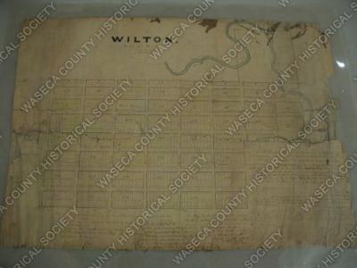
Wilton Plat Map: 1856. Material: paper, textile. Size: 22" W. x 29" L. Description: white paper mounted on linen - Manuscript Plat Map. Notarized and certified on front by John Hale Abbott, Deputy Register of Deeds for Steele County. Metes and bounds described by R.N.S. Jewett, surveyor. Legend contains lot dimensions, street and alley widths, scale, and magnetic variation. Map shows streets, blocks, numbered lots, and the line of the LeSueur River, which is tinted blue. Paper faded. Encapsulated. Edges frayed. Ink faded. Scale: 1" = 4 chains.